The French Way of St. James: the first stage over the Pyrenees from Saint-Jean-Pied-de-Port to Roncesvalles
The French Way traditionally begins in Saint-Jean-Pied-de-Port, a picturesque town on the French side of the Pyrenees. Pilgrims leave by passing through the Gate of Saint James and immediately begin the long ascent toward the Spanish border, climbing the slopes of the Col de Lepoeder. The climb winds through pastures along secondary paths, while the high-altitude trail offers spectacular views of the valleys below. Shortly after Orisson, one encounters the statue of the Virgin of Biakorri, overlooking a scenic viewpoint — a place for rest and prayer.
From this point, the path continues to ascend until it reaches the Col de Lepoeder, which at 1,430 meters is the highest point of the entire French Way. Nearby is the Izandorre shelter, a useful spot for emergency stops or shelter in case of bad weather. Although not equipped for overnight stays, it provides an emergency S.O.S. service to alert rescue teams if needed. The long descent that follows passes through dense beech forests, filled with quiet and peaceful atmospheres, eventually leading to the Collegiate Church of Roncesvalles, the first major pilgrim refuge on Spanish soil.
Some pilgrims, to lighten the stage, choose to stop in the village of Orisson, located at 800 meters above sea level, where it is possible to spend the night before facing the most demanding part of the route.
It is important to know that from November 1 to March 31, or in case of adverse weather conditions, this high mountain section is officially closed for safety reasons. In such cases, pilgrims are required to follow the Valcarlos variant, an alternative route that winds through the valley floor. This variant is less panoramic but still offers a trail rich in nature, with charming views through woods and streams accompanying the ascent toward Roncesvalles.
French Way: from Roncesvalles to Pamplona, in the heart of Navarre
After the epic crossing of the Pyrenees, pilgrims immerse themselves in a stretch of extraordinary beauty and significance: the path from Roncesvalles to vibrant Pamplona. This section is a true immersion into the identity of Navarre, winding through centuries-old forests, historic villages, and spiritual landmarks that tell the story of the Camino over the centuries.
Starting from historic Roncesvalles (Orreaga in Basque), a crossroads of faith and medieval memory, the pilgrim leaves behind the majestic monastic complex and enters a dense and silent oak forest. Here, the Pilgrims' Cross, solitary and imposing, marks one of the first iconic symbols of the Navarrese section of the Camino.
After a few kilometers, one reaches Auritz/Burguete, a mountain village with solid noble houses and a timeless atmosphere. This is the first real rest stop, with welcoming hostels, bars, and shops for supplies. Further on, the route passes through Aurizberri/Espinal, the first town of the Erro Valley, and continues through open meadows and broadleaf forests towards Bizkarreta/Gerendiain, a small settlement offering a peaceful break before the climb to the Alto de Erro, a scenic height with views over the valley below.
From here begins the descent to Zubiri, whose most famous symbol is the Bridge of Rabies, a medieval structure tied to a legend claiming that any animal passing under its arches would be miraculously cured of any disease (including rabies). Zubiri is also a crucial spot for rest and refreshment, thanks to its good range of services.
Beyond Zubiri, the Camino follows the course of the Arga River, winding through shady woods, cultivated fields, and small rural centers. Villages like Ilarratz and Larrasoaña are passed through, the latter with a long tradition of pilgrim hospitality and a tranquil atmosphere. Next come places like Akerreta, with its church surrounded by greenery, and the medieval bridge of Zuriain, continuing toward Zabaldika, where a small church offers a space for reflection and spirituality.
Approaching Villava, birthplace of cyclist Miguel Indurain, the landscape becomes increasingly urban, but the Camino does not lose its charm: parks, tree-lined areas, and green spaces accompany the pilgrim to Burlada, the last inhabited center before entering the capital.
And it is precisely here that one of the most emotional moments of the journey takes place: the triumphant entrance to Pamplona via the imposing Magdalena Bridge. The historic walls, paved alleys, and lively urban atmosphere welcome the pilgrim into a city that perfectly blends tradition, culture, and modernity.
Pamplona offers every type of service: accommodations, restaurants, tourist and pilgrim offices, places of worship, and a rich cultural life. This arrival represents the first true symbolic milestone of the Camino de Santiago, after intense days amid the natural beauty and silence of the mountains.
From the heart of Navarre to La Rioja: the French Way from Pamplona to Logroño
The route from Pamplona to Logroño is one of the richest stretches of the French Way, blending the scenic variety of Navarre with the winemaking elegance of La Rioja. Among medieval villages, Romanesque works, vineyards, and ancient monasteries, the pilgrim crosses a land where history, spirituality, and nature merge into an unforgettable experience.
The Camino de Santiago continues after leaving the historic walls of Pamplona, a city symbol of Navarre, known for its medieval fortress and the famous running of the bulls. The exit from the city passes through residential areas, parks, and quieter zones, which soon give way to hilly landscapes and dirt paths. The pilgrim is already immersed in the Navarrese countryside, with rolling views, wind turbines, and small villages scattered along the route.
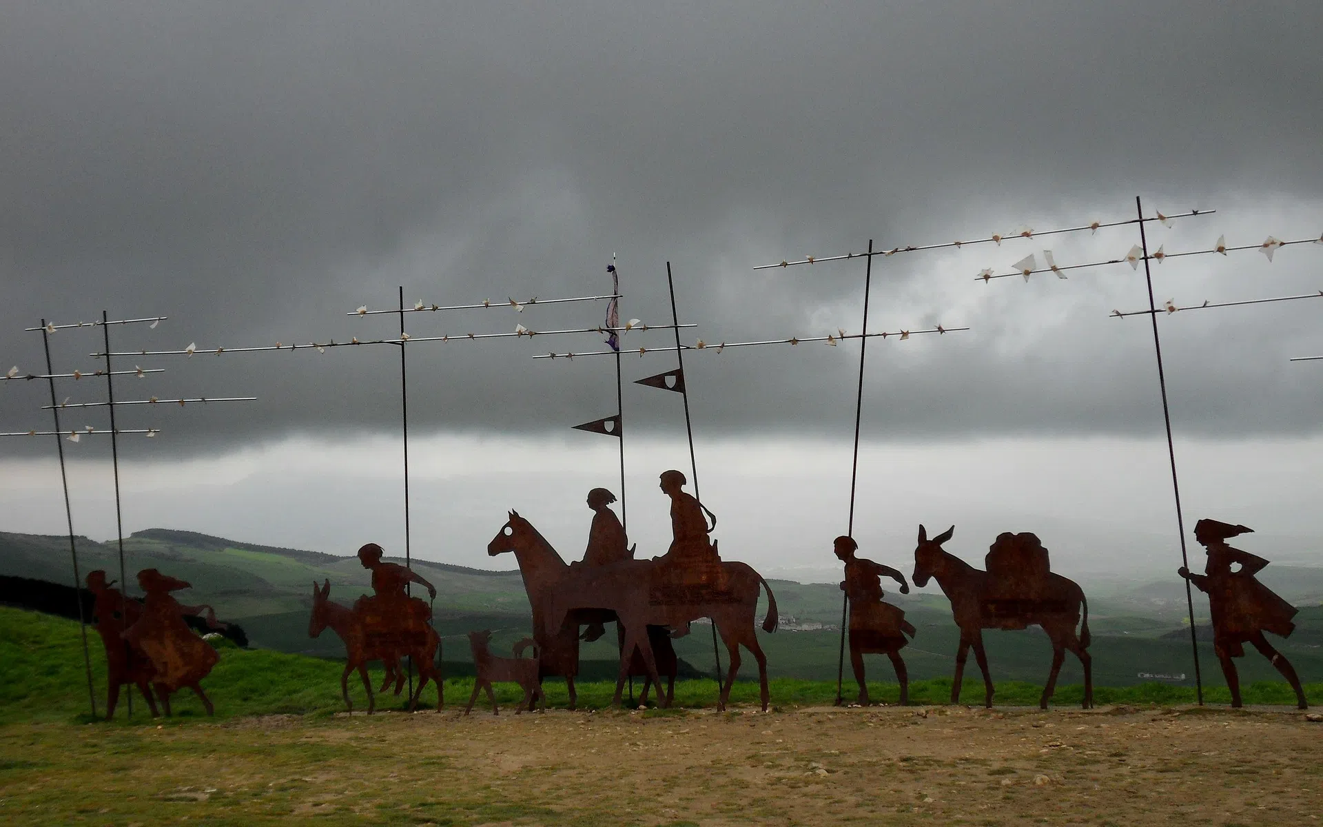
The first town encountered is Cizur Menor, known for the priory of the Knights of St. John and its Romanesque church dedicated to Saint Michael the Archangel, a witness to the long tradition of medieval hospitality. From here, the route climbs gradually toward Zariquiegui, another stone village with the church of San Andrés and its Romanesque façade.
The most emblematic point of this section is the ascent to Monte del Perdón (or Alto del Perdón), at around 800 meters. The climb, although demanding, offers wide views over the valleys of Navarre and culminates in the famous iron sculpture of the pilgrims, suspended between modernity and tradition. Among the most photographed spots of the entire route, this point combines symbolic and scenic value. The descent is steep and rocky, requiring caution but leading to more open and gentle landscapes.
After passing Uterga and Muruzábal, a detour allows for a visit to the beautiful church of Santa María de Eunate, one of the most fascinating sites on the Camino, with its octagonal plan and the mystery surrounding its origins. Shortly after, the route enters Obanos. Here, the trail converges at a crucial point: Puente la Reina (Gares), where the two great routes (from Roncesvalles and Somport) merge into the French Way. The Romanesque bridge over the Arga River, built in the 11th century by Queen Doña Mayor, is one of the symbols of the Camino de Santiago: crossing it is like stepping through a threshold into the heart of history.
After leaving Puente la Reina, the Camino enters the agricultural landscapes of central Navarre, among vineyards, olive groves, and golden fields. The first village is Mañeru, which retains a rural soul. Then comes Cirauqui, with its Roman paving, the church of San Román, and an atmosphere that evokes the past. The route continues on well-preserved sections of Roman road and crosses historic bridges like the one over the Salado River, a watercourse feared in the Middle Ages for its high salinity. Past the Alloz canal area, the trail climbs to Lorca (Navarre), dominated by the church of San Salvador, and then reaches Villatuerta, marked by the bridge over the Iranzu River and the Church of the Annunciation, where San Veremundo, patron of Villatuerta and protector of pilgrims, is venerated.
Crossing the bridge over the Ega River, one finally enters Estella (Lizarra), an important medieval center founded by the kings of Navarre specifically to welcome pilgrims. Estella surprises with its architectural heritage and ancient vocation for hospitality. Just outside the city is the famous Wine Fountain near the Monastery of Irache, where water and wine flow side by side in homage to Benedictine tradition. The Monastery of Irache, dating back to the 10th century, was long a cultural and spiritual hub of the region.
The Camino continues through agricultural paths and wooded areas, passing the villages of Azqueta and Villamayor de Monjardín, dominated by the Castle of San Esteban de Deyo and the Romanesque church of San Andrés. Here begins a long, exposed stretch, flat and solitary, leading toward Los Arcos. The approach is marked by the bulk of the church of Santa María, one of the most beautiful on the Camino, with an interior rich in Baroque chapels. The village preserves a quiet and intimate atmosphere, perfect for resting.
Beyond Los Arcos, the landscape becomes more open and rural. One encounters Sansol, a small hilltop village, and Torres del Río, where stands the Church of the Holy Sepulchre, a rare example of Templar architecture with an octagonal plan. Shortly after, one reaches Viana, the last city in Navarre. Here lies buried Cesare Borgia, son of Pope Alexander VI, who died in 1507. His tomb is located in front of the church of Santa María, in the heart of the village.
After leaving Viana, the landscape changes: vineyards become more abundant, and one enters La Rioja, a land renowned for its wine. The landscape softens, the air smells of must, and the Camino approaches Logroño, the regional capital. Entry into the city is marked by the bridge over the Ebro River. In the historic center, the Co-cathedral of Santa María la Redonda welcomes pilgrims with its twin towers and Baroque façade. The Calle Portales, the city's vibrant core, offers refreshment and culture, with ancient taverns and modern venues.
From Logroño to Burgos: the French Way between La Rioja and Castile
On the stretch from Logroño to Burgos, one leaves the fertile lands of La Rioja, cradle of fine wines and rural culture, and enters Castilian territories, the prelude to the vastness of the Meseta. In this section, the Camino de Santiago reveals its full richness: every step is an immersion into the history of Spain and the deeper meaning of pilgrimage.
Leaving Logroño, after a few kilometers one reaches Navarrete, a medieval village known for its ceramic production and the remains of the ancient hospital of San Juan de Acre, once managed by the Knights of the Holy Sepulchre. Its church of Santa María dominates the historic center, a point of rest and reflection for pilgrims.
The route continues through vineyards and cultivated fields to Nájera, a strategic city in medieval times and former capital of the Kingdom of Nájera-Pamplona. Here stands the famous Monastery of Santa María la Real, with its silent cloister and the tombs of the kings of Navarre. The town stretches along the Najerilla River, among cobbled streets and small squares that preserve the charm of the past.
From Nájera, the French Way crosses agricultural lands and gentle hills, passing through small centers like Azofra and Cirueña, custodians of an intact rural heritage. One then arrives at Santo Domingo de la Calzada, a key stop in the Jacobean tradition. Here lived Saint Dominic, who in the 12th century built roads, bridges, and hospitals for pilgrims. His name is tied to the famous miracle of the rooster and the hen, commemorated inside the cathedral, where two live birds still reside today—a living testimony of the legend.
After passing Grañón, the last village in La Rioja, the route enters the autonomous community of Castile and León, where the landscape changes: hills fade, the soil turns redder, and the fields become broader. One passes through villages such as Redecilla del Camino and Castildelgado, guardians of ancient Romanesque churches and family-run hostels, until reaching Belorado, a lively and colorful town well-equipped to welcome pilgrims.
From here, the route climbs towards the Montes de Oca, wooded hills offering shade, tranquility, and a sense of isolation in contrast with the previous plains. This section, though less rugged than the Pyrenees, is often described as "mid-mountain" and includes demanding ascents, such as the climb to the Alto de la Pedraja, which rewards with beautiful views over the emerging Castilian Meseta.
In the heart of the forest lies San Juan de Ortega, an ancient monastery founded by a disciple of Santo Domingo de la Calzada. Its Romanesque church is known for the phenomenon of the “Annunciation of Light”: twice a year, during the spring and autumn equinoxes, a ray of sunlight strikes exactly the capital that depicts in sequence the Annunciation, the Nativity, the Epiphany, and the announcement to the shepherds of the birth of Jesus.
The Camino continues toward Atapuerca, a village linked to one of the most important archaeological sites in Europe, declared a UNESCO World Heritage Site. Here were found some of the oldest prehistoric human remains in the continent—evidence of humanity’s long history in this region.
The final stretch of the Camino gradually leads to the city of Burgos, via dirt tracks and secondary roads. Pilgrims are welcomed by the majestic Gothic Cathedral of Santa María, also a UNESCO World Heritage Site, one of the most spectacular religious buildings in Spain and a symbol of Gothic art and centuries-old devotion. Burgos offers hostels, museums, and a vibrant urban life that invites one to linger.
Crossing the Meseta: The French Way from Burgos to León, A Journey into the Castilian Soul
The stretch from Burgos to León across the Meseta, while requiring considerable mental strength and preparation, is a transformative experience. The vast horizon, the near-total silence, and the repetitiveness of the landscape become tools for inner reflection, making this section one of the most profound and unforgettable of the Camino.
Leaving behind the Gothic magnificence of Burgos, the pilgrim gradually immerses into the vast and silent expanses of the Castilian Meseta, a plateau that, although seemingly monotonous at first glance, reveals a deep and austere beauty, steeped in history and spirituality. This section of the Camino Francés is crucial for understanding the most intimate essence of the journey, offering a unique opportunity for introspection.
The journey begins by leaving behind the grandiose Cathedral of Burgos, a masterpiece of Gothic architecture, and its lively streets. The transition from city to countryside is gradual, but soon the landscape opens onto cereal fields stretching as far as the eye can see. The first part of the route leads to villages such as Rabé de las Calzadas and Hornillos del Camino, ancient settlements that preserve the traditional architecture of the Meseta and offer the first taste of its vastness.
Continuing onward, the path reaches Hontanas, a green oasis nestled in the landscape, before leading to Castrojeriz. This small town is dominated by the ruins of a medieval castle, offering panoramic views over the surrounding Meseta. The pilgrim then faces the ascent to Alto de Mostelares, an elevated point that precedes a significant descent, before crossing the Canal of Castile, a historic hydraulic work that testifies to human ingenuity in these lands. The route continues to Frómista, renowned for its splendid Romanesque church of San Martín, a true architectural gem that stands alone in the landscape.
From Frómista, the Camino becomes more linear, entering the heart of the Meseta. Here, the perception of time and space shifts: the long stretches, often without shade, test the pilgrim's determination but also offer an unparalleled opportunity for reflection. Small villages like Población de Campos and Villarmentero de Campos are crossed, where the hospitality of the albergues becomes a beacon in the desert. The arrival at Carrión de los Condes marks an important stage, with its imposing Monastery of San Zoilo and the atmosphere of a bygone era.
The route continues towards Sahagún, another town of great historical significance on the Camino Francés, known as the "Capital of Romanesque-Mudejar" for its strong influence on this architectural style. This place, rich in ancient churches and convents, is a crossroads of historic routes and offers a well-deserved rest before tackling the next kilometers. The Camino from Sahagún is characterized by long tree-lined avenues that provide some shelter from the sun and wind, heading towards Mansilla de las Mulas.
The approach to León is marked by a gradual change in the landscape, from rural to more urban. The pilgrim passes through Mansilla de las Mulas, another town with a fortified appearance, preparing for the entry into the vibrant city of León. Arrival in the Leonese capital is a culminating moment: the majestic Gothic Cathedral of Santa María de Regla, with its stained-glass windows, and the Royal Collegiate Church of San Isidoro — one of the most important Romanesque complexes in the world, with the “frescoes” of its Royal Pantheon — welcome the wayfarers, offering a wide range of services, hostels, and the possibility of restorative rest after the long and evocative stages of the Meseta.
The French Way from León to the Mountains of Foncebadón
The stretch of the French Way that runs from León to Foncebadón marks a crucial and deeply evocative stage in the pilgrimage to Santiago de Compostela. Leaving behind the historical grandeur and vibrant atmosphere of León, located at about 830 meters above sea level, the traveler enters a path that, while initially retaining the characteristics of the Castilian plains, gradually but inexorably climbs toward the Montes de León. This section of the Camino Francés offers tangible evidence of Spain's geographic diversity, marking the boundary between the endless expanses of the Meseta and the embrace of the first pre-Galician hills.
The departure from León introduces the pilgrim to a landscape that, though seemingly uniform at first, conceals a subtle progression. The route crosses vast countryside, maintaining relatively steady elevations and offering an easy pace. The way comes to life upon arrival at Hospital de Órbigo, and continues toward Astorga, located at around 870 meters of elevation.
From Astorga, the landscape begins to undergo a more marked transformation. The plains of the Meseta gradually give way to a more undulating terrain, heralding the upcoming mountain climbs. The route enters increasingly wooded areas, where the air grows cooler and the vegetation denser. Small villages like El Ganso are crossed, sitting at an elevation of approximately 1015 meters, indicating the start of a more noticeable ascent. This upward phase, while not yet as rugged as the final Galician peaks, features a cumulative positive elevation gain that intensifies progressively, preparing the pilgrim for the true mountain challenge.
The arrival at Foncebadón, at about 1445 meters above sea level, marks the end of this portion of the Camino. This ancient mountain village, once an important reception center for pilgrims and later abandoned, has seen a significant revival in recent years. Located at a high elevation, Foncebadón is the starting point for the final, short but meaningful climb that leads to the Cruz de Hierro (Iron Cross, 1500 m).
From the Peaks to the Green Galician Pastures: The French Way from Foncebadón to Sarria
The stretch of the French Way that winds from Foncebadón to Sarria represents one of the most transformative and symbolically rich segments of the pilgrimage to Santiago de Compostela. Leaving behind the austere beauty of the Montes de León, the pilgrim begins a gradual descent toward the fertile plains of El Bierzo, followed by the famous ascent leading into Galicia. This section of the Camino Francés offers a remarkable synthesis of mountainous landscapes, historical heritage, and immersion in the green heart of Galician land, marking a crucial milestone in the pilgrim's inner and outer journey.
Departing from Foncebadón, set in a high mountain environment where the air is crisp and the views expansive, the route immediately begins with the short but meaningful climb to the Cruz de Hierro (Iron Cross), located at about 1500 meters above sea level. This iconic place is not only the highest point of the French Way in Spain, but also a hub of deep spirituality. Here, centuries-old tradition invites pilgrims to lay a stone at the foot of the cross, a gesture symbolizing the release of burdens, worries, or promises—a rite of liberation and hope perpetuated for generations.
Past the Cruz de Ferro, the path begins a long and meaningful descent through historic villages such as Manjarín, a Templar village that retains an almost mystical atmosphere, followed by Acebo and Riego de Ambrós, nestled in the mountainous landscape. The trail winds through forests and rocky terrain, requiring careful footing due to its sometimes uneven surface. This descent culminates in the arrival at Molinaseca, a picturesque village known for its Roman bridge over the Meruelo River—an ideal place for a refreshing break. The journey continues to Ponferrada, one of the most important towns along this stretch. With its imposing Templar Castle, Ponferrada is a historic crossroads and offers pilgrims the chance to explore a rich cultural heritage.
Leaving Ponferrada, the Camino crosses the fertile region of El Bierzo, characterized by a milder climate and the widespread presence of vineyards and orchards. Along the way are towns like Cacabelos and the majestic Villafranca del Bierzo, known as the "Little Compostela" for its Church of Santiago and the Gate of Forgiveness, which in the past allowed ill pilgrims to receive a partial jubilee without continuing further. The route follows the Valcarce River, leading to Vega de Valcarce, the last significant village before the next challenging ascent.
From here begins one of the most iconic and significant climbs of the entire Camino: the ascent to O Cebreiro. This climb, reaching about 1300 meters of altitude, marks the solemn entrance into Galicia. O Cebreiro is not just a geographical border but a place steeped in mysticism and history, famous for its pallozas—ancient pre-Roman stone dwellings with thatched roofs and thin stone blades—and for the Church of Santa María Real, where a Eucharistic miracle is said to have occurred. The atmosphere here is often shrouded in mist and rain, adding to its almost magical aura. After passing O Cebreiro, the Galician landscape unfolds in all its beauty: rolling green hills, dense oak and eucalyptus forests, and small rural villages.
The Camino continues through villages like Triacastela, where pilgrims traditionally choose between two variants: one passing through the evocative Monastery of Samos, a grand Benedictine complex, and the other more direct via San Xil. Both routes ultimately lead to Sarria, one of the most vibrant and popular towns on the Camino, located at about 440 meters of altitude. Sarria is strategically important, as it is the preferred starting point for many pilgrims who intend to walk the final 100 kilometers required to obtain the Compostela. The town offers a wide range of services, marking the end of a mountainous stretch and the beginning of the final, more crowded stage of the journey to Santiago.
This segment of the French Way, from Foncebadón to Sarria, with its significant elevation changes (from 1430m to about 440m with intermediate climbs to 1500m and then 1300m), is an experience that combines physical challenge with scenic beauty and spiritual richness, preparing the pilgrim for the thrilling arrival at the final destination.
The Last One Hundred Kilometers: from Sarria to Santiago de Compostela
The stretch of the French Way that leads from Sarria to Santiago de Compostela represents the culminating phase of the pilgrimage—an experience steeped in anticipation and profound meaning. These final 100 kilometers, the minimum requirement to obtain the Compostela, attract an increasing number of walkers, creating a unique atmosphere of togetherness. The route winds through the green heart of Galicia, offering idyllic landscapes and a growing sense of closeness to the final destination, symbolizing the perseverance and reward of the long journey undertaken.
The departure from Sarria is a symbolic moment. Many pilgrims begin their journey here, joining those who have already walked hundreds of kilometers. The atmosphere is vibrant, full of expectation, as the path immediately enters a characteristic landscape: eucalyptus forests that perfume the air, gentle hills dotted with small rural villages, and the iconic hórreos, the traditional Galician stone granaries. The trails are well-marked and generally less demanding in terms of elevation compared to previous stages, but the high density of pilgrims can make the walk an intensely social experience.
As the journey continues, the Way passes through significant locations. Portomarín, originally developed at the foot of a Roman bridge over the Miño River, was submerged with the creation of the Belesar reservoir in 1962, forcing the relocation of its most important buildings, including the beautiful Romanesque church of San Nicolás. The journey then continues through agricultural and wooded landscapes, passing through towns like Palas de Rei, which offers a wide range of services and the opportunity to restock.
Another key stop is Melide, famous throughout Galicia for its pulpo a feira (Galician-style octopus), a culinary delight that serves as a well-deserved reward for the steps taken. After Melide, the path leads to Arzúa, known for its cheese, and then to O Pedrouzo (or Arca), the last major town before Santiago. This final stage is filled with growing emotion, with each kilometer drawing ever closer to the goal. The landscape continues to be dominated by eucalyptus forests and gentle ascents and descents, maintaining a harmony that accompanies the pilgrim.
The culmination of this route comes with the ascent to Monte do Gozo (Hill of Joy), a modest rise located at about 370 meters above sea level. From this point, pilgrims can catch their first glimpse of the spires of the Cathedral of Santiago de Compostela in the distance. It is a moment of pure emotion, an explosion of joy and relief—the visual triumph after such a long journey. The final descent from Monte do Gozo leads directly into the streets of Santiago.
The entrance to Santiago de Compostela is an unforgettable experience. The path ends in the majestic Praza do Obradoiro, facing the imposing baroque façade of the Cathedral of Santiago de Compostela, where the relics of the Apostle James rest. Here, the air is thick with happiness, tears of emotion, and embraces among fellow travelers. Obtaining the Compostela, the certificate of completion of the pilgrimage, formally crowns the achievement and marks the end of a journey that is not only physical but also deeply spiritual and transformative. These last 100 kilometers, although the most crowded, are also those that crystallize the most authentic meaning of the Camino.
Santiago de Compostela: Things to Do and See After the Camino
Arriving in Santiago de Compostela is not simply the end of the French Way or any other Jacobean route, but the beginning of a new phase of discovery and celebration. After the thrilling entrance into the Praza do Obradoiro, in front of the majestic Cathedral of Santiago de Compostela, the pilgrim finds themselves immersed in a vibrant city, a UNESCO World Heritage Site, offering countless opportunities to honor their journey. A must-see is the visit to the Cathedral, the true heart of the city and the final destination of the pilgrimage. Inside, it is recommended to embrace the statue of the Apostle James and visit his crypt, moments of deep devotion and historical significance. Equally impressive is the climb to the Cathedral roofs, which offers a unique perspective on the Gothic architecture and the red roofs of the old town, a breathtaking view that rewards every effort.
Beyond the pilgrimage rituals, such as collecting the Compostela certificate at the Pilgrim's Office, Santiago invites you to explore its fascinating historic center. Getting lost among its narrow cobbled streets means discovering hidden squares, like Praza das Praterías or Praza da Quintana, and admiring the Baroque architecture that characterizes many of its buildings. The city offers a rich cultural program with museums dedicated to sacred art, the history of the Camino, and Galician culture. The culinary experience is another fundamental pillar: numerous restaurants and taverns invite you to taste local specialties, from the renowned pulpo a feira (Galician-style octopus) to very fresh seafood, accompanied by Albariño wines. To conclude the day, the lively atmosphere of markets such as the Mercado de Abastos allows you to immerse yourself in local daily life. Santiago de Compostela is not just a point of arrival, but a destination that celebrates history, faith, and culture, offering the pilgrim a well-deserved reward after a transformative journey.
Variants of the French Way: Alternative Routes and Lesser-Known Itineraries
The French Way (Camino Francés), while being the most traveled and iconic route to Santiago de Compostela, offers pilgrims several variants that allow them to tailor the journey to their needs, explore different landscapes, or deepen specific historical and spiritual aspects. These alternatives enrich the experience by offering unique perspectives and the chance to discover locations and monuments of significant interest, always keeping alive the essence of the Jacobean pilgrimage.
1. The Gateway of the Pyrenees: The Valcarlos Variant (Saint-Jean-Pied-de-Port - Roncesvalles)
The first and perhaps best-known fork appears already on the inaugural stage, between Saint-Jean-Pied-de-Port and Roncesvalles. The Napoleon Route, the main mountain path, is widely preferred for its beauty and historical significance. However, there is the Valcarlos variant, a lower-altitude alternative that follows national road N-135/D-933 for long stretches. This route, easier and less exposed to the elements, becomes mandatory during the winter months (usually from November to March) due to severe weather conditions that can make the mountain pass impassable, such as heavy snowfalls or dense fog. Passing through Arnéguy, the last French town, and arriving at Valcarlos, the pilgrim follows a path that, although less wild, guarantees a safe passage into Navarra, preserving the deep connection with the history of the Pyrenees.
2. Alternatives in the Castilian Plain: The Villar de Mazarife Variant (Leaving León)
Another significant variant appears when leaving León, offering an alternative to the official route that passes through San Martín del Camino. This option leads pilgrims toward Villar de Mazarife. While the main path follows the national road for a longer and often busier stretch, the Villar de Mazarife variant diverts onto secondary trails, crossing fields and more isolated villages. This route is sometimes preferred by those seeking greater tranquility and a closer contact with the countryside, offering a more intimate experience of the Leonese Meseta before rejoining the official Way further ahead, generally before Hospital de Órbigo, or in some cases, before Astorga, depending on the pilgrim's choices.
3. The Heart of Galicia: The Samos Variant (Leaving Triacastela)
One of the most common and meaningful choices in the heart of Galicia appears after Triacastela, about 130 kilometers from Santiago. Here, while the official route continues toward San Xil, many pilgrims opt for the Samos variant. This slightly longer detour leads to one of the most impressive and ancient monastic complexes in all of Spain, the Monastery of Samos. This majestic Benedictine abbey, with its rich millennial history and evocative cloisters, offers a unique opportunity to immerse oneself in monastic spirituality and Galician religious architecture. The path winds through ancient forests and serene landscapes, making the experience of this variant particularly meditative and culturally enriching. It is a preferred choice for those wishing to combine the physical journey with a contemplative experience of deep historical and artistic value.
These variants, scattered along the French Way, highlight the dynamic and adaptable nature of this millennial route. Each choice offers the pilgrim not only an alternative path but a different perspective on the richness of Spanish heritage and the profound diversity of landscapes leading to the final destination of Santiago de Compostela.
Beyond Santiago: The Pilgrimage to Fisterra, The Way to the End of the World
For many pilgrims, arriving at Santiago de Compostela does not mark the end of their profound journey. An increasing number of walkers choose to extend the experience by undertaking a further and evocative route towards the Galician coast: the Way of Fisterra (Finisterre). This extension of the pilgrimage, steeped in mysticism and legend, leads travelers to what was once considered the "End of the World," offering a unique perspective and a symbolic completion of the spiritual and physical path.
The Way from Santiago to Fisterra, often also called the "Extension to Finisterre" or "Way of the Death Coast," is an itinerary of about 90 kilometers, traditionally divided into 3-4 stages. Starting from the Praza do Obradoiro, where the majestic Cathedral of Santiago de Compostela stands, the route heads west, leaving the urban crowds behind to quickly immerse into the serene Galician countryside. This stretch differs from the more frequented French Way with a more intimate and reflective atmosphere, less crowded but no less charming.
The road to Fisterra passes through landscapes that progressively change, from lush forests and green fields of the Galician inland to wilder, windier coastal scenery. It touches picturesque villages like Negreira, a historic waypoint, and crosses rivers and valleys leading toward the Atlantic Ocean. A highlight of this journey is arriving at Muxía, an alternative or extension for many, famous for the Sanctuary of the Virxe da Barca, linked to Marian apparition legends and stones considered healing. Fisterra itself is the climax of this extension.
The profound meaning of the Way of Fisterra lies in its ancient symbolic value. Even in pre-Christian times, this rocky cape was seen as the extreme boundary of the known lands, a place where the sun sank into the ocean every evening, symbolizing the end of a cycle and the beginning of a new one. For Christian pilgrims, it has taken on a meaning of purification and renewal: tradition holds that upon reaching the lighthouse of Fisterra, travelers burn their clothes and bathe in the ocean waters, leaving the past behind and embracing a new beginning. The lighthouse itself, at Fisterra, stands as a symbol of guidance and hope in this iconic place, where the infinity of the ocean merges with the sky, offering a final experience of rare beauty and emotional intensity.
Choosing the Way to Fisterra means not only adding kilometers to one’s pilgrimage but enriching the experience with a unique spiritual and scenic dimension, reaching a true "end of the world" that is, at the same time, a new beginning.