With our guides you will be able to personalize duration and difficulty of the routes based on your own wishes and walking pace. In a few clicks you can create your personalized hiking guides. Choose your starting point, your arrival point and, if you wish, even a middle point where to take a break.
The Northern Way, also known as the Coastal Way, is one of the most fascinating and challenging historic routes of the pilgrimage to Santiago de Compostela. With its more than 820 kilometres crossing northern Spain along the Cantabrian coast, this ancient route offers pilgrims a unique experience, where the roar of the ocean waves accompanies the rhythm of each step and green mountains plunge dramatically into the sea.
Starting from the Basque town of Irún, on the border with France, the route crosses four autonomous communities — the Basque Country, Cantabria, Asturias and Galicia — passing through six provinces and ending in Arzúa, where it joins the famous French Way for the final stages towards Santiago de Compostela. The total length of the route far exceeds the 100 kilometres required to obtain the Compostela, the official pilgrimage certificate issued by the Cathedral of Santiago.
This coastal route stands out for the extraordinary variety of its landscapes: golden beaches lashed by Atlantic waves, vertiginous cliffs plunging into the sea, green valleys, fragrant eucalyptus forests, fishing villages with ancient maritime traditions and monumental cities rich in history and art. The path passes through places of great importance such as San Sebastián, a Belle Époque jewel with its elegant Bahía de la Concha, Bilbao, a city reborn through contemporary architecture, Santander, the noble capital of Cantabria and the evocative Asturian towns of Llanes, Ribadesella and Luarca.
The Northern Way is particularly appreciated by pilgrims seeking a less crowded alternative to the French Way, while still offering an excellent infrastructure of services, hotels and accommodation facilities. Waymarking is generally excellent, especially in the Basque section, where the iconic yellow arrows and signs bearing the scallop shell of Saint James guide pilgrims along the route.
Map of The Camino del Norte
Our guides
History and characteristics of the route
The Northern Way has its roots in medieval European history. During the early centuries of the Jacobean pilgrimage, when much of the Iberian Peninsula was still under Muslim control, this coastal route represented the safest itinerary for pilgrims coming from Northern Europe. Nobles, knights, merchants and devout Christians preferred to travel through the Christian territories of the north rather than risk crossing the lands of the Reconquista. Medieval chronicles record the passage of illustrious figures, including Saint Francis of Assisi, who according to tradition walked these paths in the 13th century.
With the progress of the Reconquista and the consolidation of the Christian kingdoms, the Camino Francés gained greater strategic and commercial importance, partially overshadowing the coastal route. However, the Northern Way never ceased to be travelled, preserving its pilgrim tradition through the centuries. Monasteries, Romanesque churches and hospices bear witness to the ancient spirit of hospitality of this land.
From a geographical and scenic point of view, the Northern Way offers unique characteristics among the Jacobean routes. Its mountainous terrain, especially in the Basque Country, imposes a demanding path, with frequent elevation changes that can exceed 600–700 metres of positive gain in a single stage. The first days of walking cross the Basque mountains, where pilgrims must tackle around ten mountain ranges rising between 300 and 500 metres in altitude. Mount Jaizkibel, with its breathtaking views over the coast of Gipuzkoa and Mount Arno near Deba, reaching almost 500 metres, are among the most memorable ascents.
In Cantabria, the route becomes gentler, alternating flat coastal stretches with mild inland undulations. Here the landscape is dominated by green meadows, eucalyptus forests planted for the paper industry and the characteristic Cantabrian rural houses. Asturias once again presents a more mountainous territory, with the imposing Mount Areo dominating the landscape shortly after Gijón, rising above 400 metres in altitude.
Upon entering Galicia, starting from the historic town of Ribadeo, overlooking the ria of the same name, the route definitively leaves the coast and heads southeast into the interior of the province of Lugo. Here the land becomes harsher and more solitary, crossing the comarca of Terra Chá, a plateau ranging between 600 and 700 metres. Before reaching the monastery of Sobrado dos Monxes, the route attains the highest point of the entire itinerary: 708 metres above sea level. From here, the path descends gently towards Arzúa, where it joins the Camino Francés for the final stretch to Santiago.
The cultural and artistic heritage along the Northern Way is extraordinary. In the Basque cities, one can admire splendid examples of Modernist and Belle Époque architecture, such as the Victoria Eugenia Theatre and Miramar Palace in San Sebastián. In Cantabria, Santillana del Mar is not to be missed, known as “the town of three lies” because it is neither saintly, nor flat, nor by the sea, yet it preserves one of the best-preserved medieval complexes in Spain, with its Collegiate Church of Santa Juliana, a jewel of Romanesque art. Nearby are the famous Altamira Caves, a UNESCO World Heritage Site, whose prehistoric cave paintings have earned the nickname “the Sistine Chapel of Paleolithic art”.
In Asturias, the route passes through Oviedo (for those who choose the Primitive Way variant), a city recognised by UNESCO for its pre-Romanesque monuments such as the Camera Santa and San Miguel de Lillo. Galicia, finally, offers masterpieces such as the Monastery of Sobrado dos Monxes, an imposing Cistercian complex with its Baroque church and three monumental cloisters.
The difficulty level of the Northern Way is considered medium to high, higher than that of the Camino Francés. The frequent elevation changes, especially in the Basque Country, require good physical preparation and well-trained legs. Weather conditions can pose an additional challenge: rain is frequent in Green Spain and the paths can become muddy and slippery. However, for hikers accustomed to mountain walking, the difficulties are amply rewarded by the beauty of the landscapes and the authenticity of the pilgrim experience.
This route is particularly suitable for pilgrims who already have trekking experience, who seek a less crowded and more contemplative path than the Camino Francés and who wish to immerse themselves in the culture of northern Spain, with its gastronomic traditions (Basque pintxos, Asturian cider, Galician octopus), its local festivals and the welcoming character of its people. It is also ideal for those who love the sea and wish to alternate walking with moments of relaxation on the Cantabrian beaches.
The Route of the Northern Way
The route begins in the border town of Irún, where the Bidasoa River marks the boundary between Spain and France. From here, the pilgrim immediately enters Basque territory, facing the first major challenge: the ascent of Mount Jaizkibel. This imposing massif rises between Irún and San Sebastián like a natural guardian of the coast and crossing it rewards walkers with spectacular views over the Bay of Biscay and the green Basque hills. The path winds through beech and oak forests, ancient rural farmhouses where Idiazabal cheese is still produced and small votive chapels recalling the passage of medieval pilgrims. The descent towards Pasajes de San Juan, a picturesque fishing village that has preserved its traditional charm, with colourful houses overlooking the natural harbour, represents one of the most emotional moments of the first stage. From here, skirting the bay, one reaches San Sebastián, a Belle Époque jewel with its elegant promenade along La Concha, its Art Nouveau buildings and the famous Parte Vieja, the beating heart of pintxos culture, where every bar is a gastronomic temptation. Leaving the capital of Gipuzkoa behind, the route continues along the coast through seaside towns such as Zarautz, with its long beach popular with surfers and Getaria, birthplace of Juan Sebastián Elcano, the navigator who in 1522 completed the first circumnavigation of the globe after the death of Magellan. This area is also famous for txakoli, the local lightly sparkling white wine, perfect with seafood.
The route becomes more demanding upon reaching Deba, where the ascent of Mount Arno begins, passing through the ancient village of Itziar with its Marian sanctuary, a destination for local pilgrimages. This climb, reaching nearly 500 metres, crosses dense forests and offers breathtaking views over the rocky coastline before descending towards Markina-Xemein, a small town with a historic centre that retains its medieval layout and is famous for the hexagonal church of San Miguel de Arretxinaga. The route then continues inland, touching Gernika-Lumo, a symbol of Basque resistance and tragically famous for the 1937 bombing immortalised in Picasso’s renowned painting. Here one can visit the Casa de Juntas, with the historic oak tree under which the assembly of Basque representatives once met. After Gernika, the path crosses gentle hills dotted with baserri, traditional Basque farmhouses, until reaching Bilbao, the capital of Biscay and a city reborn through contemporary architecture. The Guggenheim Museum, a masterpiece by Frank Gehry reflected in the waters of the Nervión estuary, transformed the former industrial city into a modern cultural metropolis. The casco viejo, the historic centre with its original seven streets and the Cathedral of Santiago, recalls the city’s medieval roots, while the pintxos of Plaza Nueva delight even the most demanding palates.
Leaving Bilbao, the route enters Cantabria via the Vizcaya Bridge, a magnificent 19th-century engineering work and UNESCO World Heritage Site, the oldest transporter bridge in the world, which still carries vehicles and pedestrians across the estuary, connecting Portugalete and Las Arenas (Getxo). The first encounter with this region is Castro Urdiales, an elegant seaside town with its imposing Gothic church of Santa María de la Asunción overlooking the harbour and its medieval lighthouse-castle of Santa Ana. The Cantabrian stretch alternates sections of asphalt along the N-634 national road, now less busy thanks to the A-8 motorway, with rural detours through valleys such as Liendo and Güemes, where time seems to stand still among green meadows and dairies producing the famous Cantabrian cheese. Laredo, with its vast Playa de la Salve stretching over four kilometres, offers a restorative stop where many pilgrims choose to enjoy a swim in the Cantabrian waters. From here, crossing the estuary by boat or following the inland alternative route, one reaches Santoña, an important fishing port famous for its anchovies, before continuing towards Santander. The capital of Cantabria welcomes pilgrims with its majestic bay, the Magdalena Palace overlooking the sea, the refined Sardinero Beach, frequented by Spanish aristocracy since the 19th century and the modern Centro Botín designed by Renzo Piano.
Leaving Santander, the route passes through some of Cantabria’s most enchanting towns. Santillana del Mar, a perfectly preserved medieval village with noble houses, flower-filled balconies and cobbled streets, is an essential stop. Nearby, the already mentioned Altamira caves preserve extraordinary examples of prehistoric rock art. Continuing along the coast, one reaches Comillas, where Catalan Modernist architecture has left its mark with El Capricho by Gaudí, an eccentric neo-Gothic palace with a cylindrical tower resembling a minaret, decorated with colourful ceramics and wrought-iron sunflowers and the Sobrellano Palace, the summer residence of the Marquis of Comillas. Crossing into Asturias near Colombres, where Indian-style architecture bears witness to the return of migrants enriched in the Americas, the pilgrim enters the Principality of Asturias. The Asturian coast reveals all its wild beauty, with sheer cliffs, hidden coves and unique natural phenomena such as the bufones, sea-water geysers that erupt through cracks in the rocks during storms.
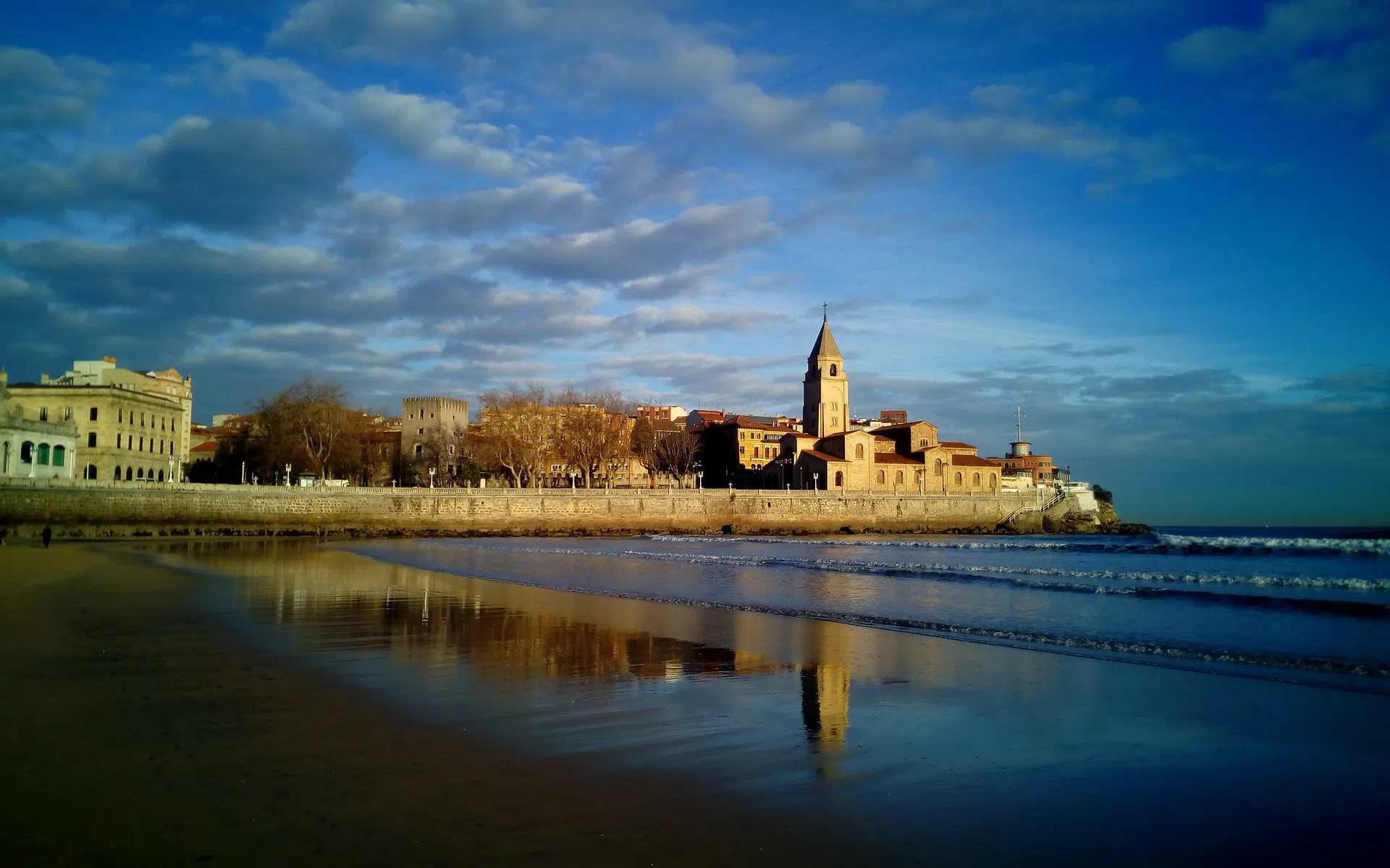
Llanes welcomes visitors with its charming fishing harbour, the noble houses of its historic centre and the Cubos de la Memoria, an artwork by Basque artist Agustín Ibarrola, who painted the harbour breakwaters with vibrant colours, transforming concrete blocks into works of art reflecting local symbols and culture. Continuing towards Ribadesella, the route passes through seaside villages such as Nueva and La Isla, before reaching the mouth of the River Sella, famous for the international canoe descent held every August. From here, pilgrims must choose: continue along the coast towards Gijón or head inland by taking the Camino Primitivo towards Oviedo, the ancient capital of the Kingdom of Asturias. Those who choose the coastal route proceed through Villaviciosa, a land of apples and cider, where apple orchards cover the hills and sidrerías offer an authentic experience of Asturian cider culture, recently recognised by UNESCO as Intangible Cultural Heritage. Gijón, the most populous city in Asturias, with its old fishing district of Cimadevilla perched on a promontory, the Roman baths of Campo Valdés and the modern Scientific and Technological Park, presents an interesting contrast between tradition and modernity. Leaving Gijón, the ascent of Mount Areo through eucalyptus forests offers a peaceful interlude before descending towards Avilés, an industrial city that has successfully renewed itself culturally thanks to the Niemeyer Centre, an internationally renowned cultural complex designed by Brazilian architect Oscar Niemeyer, characterised by its distinctive white, curving forms.
The western Asturian stretch of the route winds through small rural villages, eucalyptus forests and occasional panoramic openings onto the ocean. Muros de Nalón retains the charm of a small river port, while Soto de Luiña represents one of the most solitary and rural stages of the route. Cadavedo, with its sweeping ocean views and the cliffs of Cape Vidio, offers unforgettable sunsets. Luarca, known as “the white town of the green coast”, is one of the most picturesque fishing villages in Asturias, with white houses cascading down towards the natural harbour, a cemetery overlooking the sea and the chapel of Our Lady of Luarca. The route continues through Navia, crossed by the river of the same name and La Caridad, before reaching the Galician border at Ribadeo, an elegant town overlooking the ria that separates Asturias from Galicia. From here, one can visit the famous Playa de las Catedrales, with its spectacular rock arches sculpted by marine erosion, accessible only at low tide.
Upon entering Galicia, the Northern Way definitively leaves the ocean behind and heads inland into the province of Lugo. Lourenzá welcomes pilgrims with its imposing Monastery of San Salvador, a Benedictine complex with a richly decorated Baroque church. Nearby, Mondoñedo, one of the seven ancient capitals of Galicia, surprises visitors with its Gothic cathedral dedicated to the Assumption, narrow medieval streets and noble palaces. The landscape becomes harsher and more mountainous, crossing countless rural parishes where stone houses with their hórreos (traditional Galician raised granaries) testify to a way of life still closely tied to the land and its traditions. After Gontán, the route enters the plateau of Terra Chá, a vast gently undulating plain where cultivated fields alternate with pastures and eucalyptus and pine forests. Vilalba, with its imposing Andrade Tower, a medieval fortress converted into a Parador hotel, represents an interesting example of Galician architecture. Continuing south through Baamonde and Miraz, tiny rural settlements that keep pilgrim hospitality alive with modest albergues run by volunteers, the route reaches one of the most majestic places along the entire journey: the Monastery of Sobrado dos Monxes. This imposing Cistercian complex, founded in the 10th century and rebuilt in the Baroque period, impresses with its monumental scale, three cloisters and grand church with its dome and side chapels. Here pilgrims can stay overnight in the hostel run by the monks, attend liturgical services and experience the contemplative silence that permeates the monastery atmosphere.
From Sobrado, the route descends gently through forests and meadows towards Arzúa, where the Northern Way finally meets the Camino Francés. In this small town in the province of Lugo, famous for its PDO cheese and gastronomic festivals, pilgrims arriving from Irún join the flow of walkers coming from Saint-Jean-Pied-de-Port, Roncesvalles, León, or Sarria. From here, the final two stages through Pedrouzo lead to the ultimate destination: Santiago de Compostela, where the cathedral, with its twin towers rising above the Plaza del Obradoiro, welcomes pilgrims who have walked over 800 kilometres of coastlines, mountains and plains. Arrival in the holy city, the embrace of the Apostle in the cathedral crypt, the receipt of the Compostela certificate and participation in the Pilgrims’ Mass with the great botafumeiro swinging through the central nave represent the culmination of an experience that has transformed not only the body but also the spirit of those who have walked the Northern Way.
How to get to Irún
Reaching Irún, the starting point of the Northern Way, is relatively straightforward thanks to its strategic location on the Franco-Spanish border and its good connections with major European cities.
By Plane: The closest airport to Irún is San Sebastián Airport (EAS), located about 20 kilometers away in the town of Hondarribia. However, this airport offers limited connections, mainly with Madrid and Barcelona. A much more convenient alternative with a wider range of international connections is Biarritz–Pays Basque Airport (BIQ) in France, located about 30 kilometers from Irún. This airport is connected to numerous European cities, especially during the summer season. From Biarritz, Irún can be reached by bus or taxi. Another option is Bilbao Airport (BIO), the largest airport in northern Spain, located about 100 kilometers from Irún. From Bilbao, there are direct flights from many European and Spanish cities. From Bilbao Airport, you can take a Bizkaibus bus to the Termibus station in Bilbao and from there a PESA bus or a direct train to Irún.
By Train: Irún is an important international railway hub. Irún-Ficoba station is served by high-speed trains (AVE) from Madrid (approximately a 5-hour journey), Barcelona and other Spanish cities. In addition, Irún is connected with France: from the nearby French town of Hendaye (reachable on foot or in a few minutes by local train), there are direct trains to Paris, Bordeaux and other French destinations. The regional railway service Euskotren connects Irún with San Sebastián, Bilbao and other Basque towns with high frequency. To check timetables and book tickets, you can consult the websites of Renfe (www.renfe.com) for Spanish trains and SNCF (www.sncf.com) for French connections.
By Bus: Several bus companies connect Irún with major cities in northern Spain and France. The company PESA (www.pesa.net) offers frequent connections with San Sebastián, Bilbao, Vitoria-Gasteiz and other Basque towns. ALSA (www.alsa.es), Spain’s main bus company, connects Irún with Madrid, Barcelona, Santander and many other destinations. From France, FlixBus offers low-cost connections from various European cities. Irún’s bus station is located on Paseo de Colón, close to the city center and the railway station.
When to walk the Northern Way
Choosing the best time to undertake the Northern Way depends on several factors: weather conditions, the number of pilgrims, availability of services and personal preferences. Green Spain, as this coastal region is known, is characterized by an oceanic climate with frequent rainfall throughout the year, mild temperatures and high humidity.
Spring (April–June) is considered one of the best times to walk the Northern Way. Temperatures are pleasant, ranging between 15 and 20 degrees Celsius, the landscapes are lush and green thanks to spring rains and wildflowers brighten the meadows along the route. Pilgrim numbers are moderate, making it easier to find accommodation in albergues and to enjoy a more peaceful atmosphere. However, rain is still frequent, especially in April and May, so good waterproof gear is essential. Services such as bars and restaurants are fully operational and many seasonal accommodations reopen towards the end of April or the beginning of May.
Summer (July–August) is the peak pilgrim season on the Northern Way. Temperatures are warm, averaging between 20 and 25 degrees Celsius, although they can exceed 30 degrees in inland areas during the hottest hours of the day. The main advantage is the lower likelihood of rain and the opportunity to swim in the many beaches along the route. All services are open and operational. The downside is the high number of pilgrims, especially in August, when many Spaniards walk the Camino during their summer holidays. Public albergues can fill up quickly, making advance booking of private accommodation advisable. Coastal towns and tourist cities are crowded, driving up prices and reducing the sense of tranquility that many pilgrims seek.
Autumn (September–October) is probably the most recommended period to walk the Northern Way. Temperatures remain mild, between 15 and 20 degrees Celsius, the number of pilgrims decreases significantly compared to summer and the autumn light gives the landscapes particularly evocative golden hues. September, in particular, often offers fine weather with still-summery temperatures but without excessive heat. Rainfall gradually increases towards November but remains manageable. Services remain fully operational until the end of October, when some seasonal accommodations begin to close. The grape harvest and apple picking for cider enliven the Basque, Cantabrian and Asturian countryside, offering pilgrims the opportunity to take part in traditional rural festivals.
Winter (November–March) is the most challenging period to tackle the Northern Way. Temperatures drop, ranging between 5 and 12 degrees Celsius and rainfall is frequent and heavy, making paths muddy and slippery. However, for those seeking an authentic, solitary and contemplative pilgrimage experience, winter can offer a unique atmosphere. Pilgrim numbers are minimal, albergues are almost empty and the cost of living is lower. The main drawback is the closure of many services: numerous seasonal albergues remain closed, some bars and restaurants in smaller villages do not open daily and ferry services across the rías may be suspended, forcing long inland detours. It is essential to check accommodation availability in advance and plan stages carefully. Snow is rare along the coast but can occur in the Basque mountains and in inland Galicia.
In conclusion, the best time to walk the Northern Way is generally considered to be late spring (May–June) and early autumn (September–early October), when favorable weather conditions, beautiful landscapes, a moderate number of pilgrims and fully operational services come together.
Practical advice for the Pilgrim
The Northern Way offers an excellent network of pilgrim accommodation. Public or municipal albergues, run by local authorities, provide low-cost lodging (generally between 7 and 12 euros per night) with essential services: bunk beds in shared dormitories, equipped kitchens, showers and sometimes washing machines. These albergues operate on a “first come, first served” basis, without reservations and generally open in the early afternoon. Private albergues offer greater flexibility, often allowing advance booking and may include additional services such as breakfast, luggage transport, or private rooms. Prices range between 10 and 20 euros. In larger cities and tourist areas, guesthouses, hostels, hotels and rural accommodations are available for those seeking more comfort and privacy. In the Basque Country and Cantabria, the accommodation network is particularly well developed, while in inland Galicia the density of services decreases, making more careful stage planning necessary.
The Pilgrim’s Credential (Credencial del Peregrino) is the essential document required to access public albergues and to obtain the Compostela at the end of the Camino. It is a kind of passport that must be stamped (sellar) at least once a day along the route, at albergues, parishes, bars, restaurants, tourist offices and other stamping points. In the final 100 kilometers before Santiago, at least two stamps per day are required to prove that the route has been walked on foot. The credential can be obtained from Camino de Santiago associations in Italy or directly in Irún, at the tourist office or the first albergue. The cost is symbolic, generally around 2–3 euros.
The signposting of the Northern Way is generally good, with the characteristic yellow arrows painted on walls, trees, poles and road signs, along with mojones (vertical markers) indicating the remaining distance to Santiago. In the Basque Country, signposting is excellent, with clear and frequent indications. In Cantabria and Asturias, the marking is overall reliable, although in some sections it may be less evident, especially in urban areas or forests. It is advisable to carry a printed guidebook or a dedicated GPS app for the Camino, such as Gronze, Buen Camino, or Wikiloc, to avoid getting lost in more critical sections. Particular attention should be paid in areas with multiple variants, where it is important to verify which route you intend to follow. During periods of heavy rain or fog, the visibility of yellow arrows may be reduced, making it essential to proceed with caution and check directions frequently.
As for equipment, it is essential to carry a good waterproof jacket or poncho, waterproof hiking shoes and preferably a second pair of footwear to rest your feet. Trekking poles are recommended due to the mountainous nature of the route. A lightweight sleeping bag is necessary in albergues, although in summer a sleeping bag liner may be sufficient. It is important to travel light, with a backpack that does not exceed 10% of your body weight. Basic medications, blister plasters and anti-chafing creams complete the essential kit.
Why choose the Northern Way
The Northern Way is an ideal choice for pilgrims seeking a more authentic, intimate and contemplative experience compared to the much busier French Way. The peaceful atmosphere that permeates this route allows pilgrims to rediscover the true essence of pilgrimage: the silence of the forests, the slow rhythm of walking and a deep encounter with oneself and with fellow pilgrims.
The lower number of pilgrims compared to the French Way is one of the main advantages of the Northern Way. While the French Way sees over 300,000 pilgrims each year, the Northern Way welcomes around 20,000–25,000 walkers, numbers that make it easier to find accommodation in albergues (except during the August peak) and to enjoy a more personal and less standardized experience. This aspect is particularly appreciated by those who have already walked the French Way and are looking for a new challenge, or by those who wish to avoid the excessive commercialization that characterizes some sections of the more popular route.
The uniqueness of the landscapes is perhaps the greatest treasure of the Northern Way. Few European routes can boast such geographical and scenic variety: dramatic cliffs plunging into the Atlantic, golden beaches where pilgrims can enjoy a refreshing swim after hours of walking, green Basque mountains reminiscent of Irish landscapes, fragrant eucalyptus and pine forests, quiet rural villages where time seems to stand still and monumental cities rich in history and culture. The constant presence of the sea, even when it is not directly visible, gives the Camino a special energy, a rhythm marked by the tides and the breathing of the ocean.
The cultural and gastronomic richness of northern Spain is another irresistible reason to choose this route. The Basque Country offers the experience of pintxos, small culinary masterpieces that turn every bar into a laboratory of gastronomic creativity, accompanied by txakoli, the local lightly sparkling white wine. Cantabria delights with its cheeses, Santoña anchovies and sobaos pasiegos, traditional sweet pastries. Asturias introduces pilgrims to cider culture, an emblematic drink poured by “escanciando” (from a height into the glass to aerate it) and to fabada, a hearty bean and pork stew. Galicia, finally, offers its famous Galician-style octopus, Arzúa cheeses and Albariño wine. Each region has its own traditions, festivals, music (from the Basque txistu to the Galician gaita) and languages (Basque, Asturian, Galician), creating a cultural mosaic of extraordinary richness.
The spiritual and contemplative experience on the Northern Way takes on a particular dimension thanks to the relative solitude of the route, the grandeur of nature and the presence of places of great religious and historical significance. Cistercian monasteries such as Sobrado dos Monxes, ancient Romanesque churches hidden in Basque valleys, Marian sanctuaries perched on hilltops and the small votive chapels scattered along the way all invite prayer, meditation and reflection. The sound of bells calling the faithful to evening mass, the warm welcome of hospitable friars and the sacred silence of medieval cloisters help create an atmosphere that encourages inner recollection and the search for meaning that many pilgrims seek on the Camino.
This route is particularly suited to experienced hikers with good physical preparation, capable of tackling significant elevation changes. It is ideal for those with prior mountain trekking experience who are looking for a demanding yet rewarding journey. It is perfectly suited to pilgrims who have already walked the French Way and wish to discover a new, less touristy and more authentic dimension of the Jacobean pilgrimage. It is the perfect choice for sea lovers who want to alternate walking with moments of relaxation on Cantabrian beaches, enjoying the sea breeze and sunsets over the ocean. It also appeals to cultural travelers interested in deeply exploring the traditions, gastronomy, art and history of northern Spain, far from mass tourism circuits. Finally, it is especially suitable for contemplative pilgrims seeking silence, reflection and inner growth, away from the noise and frenzy of the contemporary world.
The Northern Way is, ultimately, a journey into the soul of Green Spain, a deep immersion in landscapes where wild nature and millennia-old culture blend into a transformative experience that leaves indelible memories in the heart and mind. It is a Camino that does not merely lead to Santiago de Compostela, but becomes itself a destination and a meaning, teaching that the journey is more important than the destination, that every step is a prayer, that every encounter is a gift and that the true Compostela is found within us, in a heart transformed by the walk.
Plan your route with the The Camino del Norte App
Download or print the PDF guide of The Camino del Norte
The Forwalk paper guide is an A5 format mini-book with all the information on your chosen paths, the detailed maps, the list of hotels and much more. It is very easy to consult and to carry along during your trip. This guide is completely personalized to your needs and made available to you digitally (Acrobat Reader PDF file), to be accessed through smartphones and tablets or printed by you. You can also order it already printed in color on glossy paper, and delivered to you as a finely bound book.
Download the gpx routes map of The Camino del Norte
GPX tracks are maps that you can download on GPS device to take with you on your walk. Our GPX tracks include routes with details of places such as shops, restaurants, lodgings, drinking fountains and springs.
- Download Irun to Santiago de Compostela
- Download From Bilbao to Santiago in one month
- Download Gijon to Santiago in 15 days
- Download The coastal route from Bilbao to Santander
- Download The last 100 Km from Baamonde
Our GPX tracks are tested on the following devices : Garmin ETREX 22x, Garmin eTrex Touch 35, Garmin Oregon 700, Garmin GPS MAP 66