With our guides you will be able to personalize duration and difficulty of the routes based on your own wishes and walking pace. In a few clicks you can create your personalized hiking guides. Choose your starting point, your arrival point and, if you wish, even a middle point where to take a break.
The Camino de los Faros
Way of the Lighthouses from Malpica to Finisterre, a coastal route along the Costa da Morte in Galicia
go to the guides
The Lighthouse Way (O Camiño dos Faros) is a 200-kilometre route that connects the seaside town of Malpica with the legendary Cape Finisterre, winding along the wild Costa da Morte, in the province of A Coruña, Galicia. The sea is the absolute protagonist of this walk, which quite literally embraces the ocean for its entire length, passing all the lighthouses and the main points of interest along this fascinating and rugged coastline.
Unlike the traditional Jacobean routes, this path celebrates the age-old relationship between humankind and the Atlantic Ocean, crossing landscapes of primordial beauty: deserted beaches, silvery dunes, vertiginous cliffs, estuaries, forests overlooking the sea and ancient fishing villages. The route, recognised by the prestigious British newspaper The Telegraph among the “50 greatest adventures in the world”, offers a total immersion in Galician wilderness, among prehistoric dolmens, Celtic fortified settlements (castros) and, of course, the lighthouses that for centuries have guided sailors through these feared and respected waters.
Map of The Camino de los Faros
Our guides
History and characteristics of the route
The Costa da Morte owes its name to its tragic history. This stretch of coastline holds the world record for the number of shipwrecks over the centuries: intense maritime traffic, treacherous rocks rising from the sea, strong currents and fearsome storms have made these waters the most dangerous in Europe. The name “Costa da Morte” itself first appeared in 1904 in the Coruña newspaper Noroeste, following the shipwreck of the English vessel Serpent, which in 1890 caused the death of almost 200 British sailors. It was precisely after this tragedy that the British authorities urged the strengthening of coastal signaling, leading to the construction of numerous lighthouses between the 19th and 20th centuries, including the majestic Vilán Lighthouse, the first electric lighthouse, inaugurated in 1896.
The Lighthouse Way, in its current form, was created in December 2012 thanks to the initiative of a group of Galician friends, affectionately known as the “Trasnos” (goblins), who decided to explore the paths used by fishermen and percebe collectors (the crustaceans that grow on wave-battered rocks) in order to create a continuous route along the coast. Over several weeks they completed the undertaking, linking Malpica to Finisterre while staying as close to the sea as possible. What began as a personal adventure turned into a collaborative, non-profit project, giving rise to one of the most spectacular coastal trails in Galicia, if not in all of Europe.
The route has a medium level of difficulty that tends to increase progressively as the stages advance. The coastline is steep, with a total elevation gain of 5,000 meters and an equal 5,000 meters of descent. The terrain is varied: narrow paths among rocks, sandy beaches, wooded sections and occasional stretches along rural roads. The waymarking, made up of green arrows and footprints painted on the rocks, guides walkers through this natural labyrinth, where every bend in the path reveals a breathtaking view over the Atlantic.
The Route of the Camiño dos Faros
The journey begins in the small port of Malpica, an authentic fishing village where the salty scent of the sea blends with the wind. From here, the path heads north, skirting a series of beaches set between the cliffs: Playa de Area Maior, the wild Seaia, Beo with its turquoise waters, Seiruga and Barizo. On the horizon, the enigmatic silhouettes of the Sisargas Islands come into view, a refuge for cormorants and seagulls, while the first lighthouse on the route, Punta Nariga, watches over the coast with its distinctive white tower. The path continues toward the spectacular Playa de Niñóns, a hidden gem reached via a demanding trail that winds its way through the cliffs.
From Niñóns, the route crosses small coves and rocky headlands before reaching Ponteceso, the birthplace of Eduardo Pondal, the poet who wrote the anthem of Galicia. Here the path crosses the bridge over the Anllóns River and temporarily leaves the coast to head inland, encountering two archaeological treasures: the magnificent Dolmen de Dombate, one of the most important monuments of Galician megalithic art, decorated with polychrome rock carvings and the Castro de Borneiro, an ancient Celtic settlement that still preserves traces of its circular walls. This stretch culminates at the summit of Monte Castelo de Lourido, the highest point of the entire route at 312 meters above sea level, from which the view opens onto an endless panorama of ocean and land.
Descending from the mountain, the trail returns to the coast, exploring the rugged shoreline of Cabana de Bergantiños, a succession of sea caves, hidden beaches and rock formations shaped by millennia of erosion. It passes Punta do Cabalo before reaching Laxe, a seaside town overlooking a wide bay of white sand. After a climb, the route reaches the Laxe lighthouse, built in 1920, from which two natural wonders can be admired: the cove of A Furna da Espuma and the glass beach, Praia dos Cristais.
From the lighthouse, the route follows the Enseada da Baleeira, immediately offering wide views of Roccia do Castro, Ruta da Insua and Soesto Beach. The coastal path runs above the cliffs and leads toward Punta de Catasol, then descends onto the broad sandy shore of Soesto, characterized by pale sand and powerful waves crashing against the ocean. Behind the beach stretches a lagoon area.
Leaving Soesto via wooden boardwalks, the route continues toward Traba Beach, crossing an environment dominated by sandy dunes and a lagoon surrounded by reed beds. This protected area is frequented by walkers and cyclists and is an important observation point for numerous bird species, especially during the winter months and the nesting season. The vegetation is typical of the Galician coast, with species adapted to sandy, saline soils.
At the end of Traba Beach, the route reaches Mórdomo, where the path resumes along the coastal trail, entering one of the most evocative sections of the Camiño dos Faros. The landscape changes again as it approaches O Cuello da Señora, a protected area characterized by large granite rocks sculpted by wind and sea, forming a true natural amphitheater framed by pine forests.
The route continues among cliffs and smoothed rocks to Coído de Sabadelle, a pebble beach that preserves memories of its past as a whaling port. Shortly after, the path reaches Camelle, entering from the sea and the small fishing harbor. The village is known for the museum dedicated to Man, the German artist who lived here for many years and for his house with a sculpture garden overlooking the coast.
From Camelle, the path becomes gentler, crossing fields and rural areas as far as Porto da Lagoa, with its large beach and calm waters. The final stretch leads to Arou, a small village where traditional granaries can be seen and local life remains strongly tied to tradition.
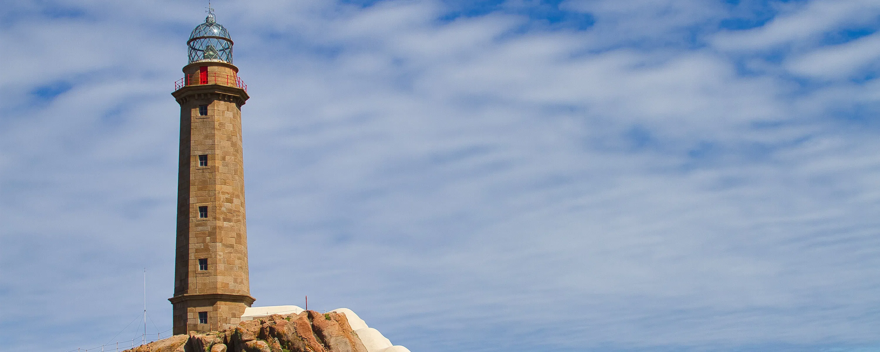
From here begins one of the finest hiking trails and the Costa da Morte reveals its harshest face: the cliffs of Cabo Roncudo, with its historic lighthouse, rise like bastions against the fury of the ocean, while Playa de Lobeiras and the surroundings of Cabo Vilán preserve tangible evidence of maritime tragedy, including the evocative Cemetery of the English, where the sailors of the Serpent rest. It is here that the Vilán Lighthouse stands, one of the most imposing in Galicia and a magical place on the Camiño dos Faros.
From Vilán, following a coastal path, the route reaches the small harbor of Camariñas. From here, the trail undertakes its longest stage, crossing the entire Ría de Camariñas. The landscape changes in character: quiet villages, serene beaches at the mouth of the Río Grande and the extraordinary Praia do Lago accompany the walker all the way to Muxía, one of the most spiritually charged places in all of Galicia. After climbing Monte Corpiño, the route reaches the Santuario da Virxe da Barca, one of the most venerated Marian shrines on the Iberian Peninsula, surrounded by legendary rocks to which tradition attributes miraculous powers. The Muxía lighthouse, located nearby on a windswept promontory, offers breathtaking views over the immensity of the Atlantic, while a short distance away stands La Ferida, a moving sculpture dedicated to the victims of the Prestige oil tanker disaster of 2002.
From here begins the most demanding section of the route, characterized by 10 kilometers of continuous ups and downs from Lourido to Moreira. After reaching Moreira Beach, the stage enters a second, decidedly easier part. From here, the route continues along a dirt road leading to Touriñán, where the Touriñán Lighthouse rises on the right: this is the westernmost point not only of the Camiño dos Faros, but of all mainland Spain. In the final part of the route, the path crosses Insua do Castelo and Coído de Touriñán, before climbing to the Mirador. From here, following a road that passes near the small village of Talón, the trail finally reaches Nemiña Beach. The final stretch of the route starts from this very beach, a sweep of golden sand nestled between granite cliffs and winds through increasingly wild and solitary landscapes. It passes the Castro de Castromiñán, an archaeological site where the outer walls are barely visible and climbs Monte do Facho, a summit considered sacred since pre-Roman times. And then, after days of walking, the Finisterre Lighthouse finally appears, the last guardian of the coast, standing on the rocky promontory that for centuries was considered the western edge of the known world. Here, where Europe plunges into the ocean, the journey finds its natural conclusion, as the sun sets, coloring the waters red and gold and offering the pilgrim a moment of pure contemplation before infinity.
How to get to Malpica
By Plane and Bus: The most practical way to reach the starting point of the Camino dos Faros is to fly to A Coruña Airport or, alternatively, to Santiago de Compostela Airport. From the A Coruña bus station, you can take an Arriva Galicia bus that connects the city with Malpica, with a change in Carballo (the total journey takes about 2 hours). Alternatively, from Santiago Airport you can reach Coruña by train or bus and then continue by bus (see above), or take a bus to Malpica with a change in Carballo. It is advisable to check updated timetables on the Transporte de Galicia and Arriva Galicia websites.
By Train: RENFE’s railway network connects Galicia with the rest of Spain and Europe. The nearest railway stations to Malpica are located in Santiago de Compostela and A Coruña, from where high-speed (AVE) and regional trains depart to major Spanish cities. From Santiago station, you can take a Transporte de Galicia bus that connects with Malpica in about 1 hour and 35 minutes (the service departs from the Vista Alegre stop). An alternative option is to take a regional train to A Coruña and then continue by bus to Malpica.
When to walk the Camino dos Faros
Galicia is characterised by an Atlantic climate with abundant rainfall throughout the year, but each season offers a different experience along the Camino dos Faros.
Spring (April–June): is probably the ideal period: coastal meadows fill with wildflowers, temperatures are mild (15–20°C) and the days grow longer, offering more daylight hours for walking. Rain is still frequent but generally short-lived and the landscape appears at its lush green peak.
Summer (July–August): brings warmer (20–25°C) and less rainy days, but it is also the busiest tourist season, especially in well-known destinations such as Muxía and Finisterre. The long summer days allow you to enjoy late sunsets over the ocean and the water temperature becomes ideal for swimming at the beaches along the route. However, morning fog can still occur even in summer.
Autumn (September–November): offers a distinctive light, with warmer colours and a melancholic atmosphere that perfectly matches the character of the Costa da Morte. September and October are still relatively mild, with pleasant temperatures and fewer tourists. From November onwards, rainfall increases and daylight hours shorten significantly, making the walk more demanding and, in some rocky sections, potentially dangerous due to slippery ground.
Winter (December–March): is not recommended for walking the entire route unless you are a very experienced hiker. Daytime temperatures range between 10 and 15°C, but humidity and Atlantic winds make it feel much colder. Rain is frequent and heavy and storms can last for days. In addition, some accommodation and dining services may be closed during this period. However, for those seeking absolute solitude and who are not deterred by harsh weather, winter offers the opportunity to experience the Costa da Morte in its wildest and most authentic form, with stormy seas crashing against the cliffs in a display of primordial power.
The recommended best period runs from May to early October, with a particular preference for May–June and September, when there is the best balance between favourable weather conditions and lower visitor numbers.
Practical advice for walkers
Unlike the traditional Camino routes to Santiago, the Camino dos Faros does not have a widespread network of pilgrim hostels. The only albergues are located towards the end of the route, in the towns of Muxía, Lires and Finisterre, thanks to the overlap with the popular Camino to Finisterre and Muxía. There is also a shared dormitory in Camelle. For the rest of the route, accommodation must be found in hotels, guesthouses, rural houses or tourist apartments. The good news is that, outside the peak summer season, accommodation prices on the Costa da Morte are generally affordable. It is essential to book in advance, especially in the early stages where accommodation options are limited or even absent at the suggested stage endpoints. Many walkers choose to modify the original stage plan to match locations where suitable accommodation is available, sometimes relying on local taxis to reach the starting point of the following day.
Waymarking along the route is generally good, consisting mainly of green arrows and the distinctive painted footprints found on the rocks along the paths traditionally used by percebes (goose barnacle) gatherers. However, in some more remote sections the signs may be less frequent and during certain times of the year invasive vegetation can obscure the trail. Downloading GPX tracks is strongly recommended. In several areas, especially inland and along some cliffs, mobile phone coverage may be absent, so it is essential not to rely exclusively on your phone.
Equipment should be chosen carefully: sturdy hiking boots with a good non-slip sole are essential, as the terrain constantly changes between rocks, sand, muddy paths and occasional stretches of asphalt. Trekking poles are highly recommended to tackle the many ascents and descents and to maintain balance on rocky sections. A high-quality waterproof jacket is absolutely necessary: in Galicia it is said that there is no bad weather, only inadequate clothing. Bring a waterproof backpack or a rain cover, as well as dry bags to protect electronics and documents. Sunscreen and a hat are essential, as even under cloudy skies the reflection of the sun on the ocean can cause sunburn. Do not forget a large water bottle: on some stages, potable water can be difficult to find.
As for food, larger towns such as Ponteceso, Laxe, Camariñas, Muxía and Finisterre have supermarkets and bars where you can resupply, but it is wise to always carry energy snacks such as dried fruit, energy bars and chocolate, as refreshment points are scarce or nonexistent on some long stages. Galician cuisine deserves to be savoured: Galician-style octopus, fresh percebes, the catch of the day, empanadas filled with tuna or meat and local cheeses. Accompany your meals with a glass of Albariño or Ribeiro, the region’s typical white wines, perfect with seafood.
Why choose the Camino dos Faros
At a time when the most famous routes, such as the Camino de Santiago, are experiencing an exponential increase in pilgrim numbers, the Camino dos Faros represents a valuable alternative for those seeking authenticity and solitude. During entire days of walking, it is possible to encounter only a handful of other hikers and many of the beaches crossed remain completely deserted even in the height of summer. This intimate dimension allows for a deep connection with nature and with oneself, far removed from the frenzy and overcrowding that characterise more popular routes.
The uniqueness of the landscapes is perhaps the element that most distinguishes this route: the Costa da Morte is a concentration of wild beauty where the Atlantic Ocean reveals itself in all its forms, from the crystal-clear calm of sheltered coves to the fury of waves crashing against cliffs during stormy days. The colours of the sea change constantly, from deep turquoise to stormy grey, creating a visual spectacle that is never the same twice. The sunsets that can be admired from these places are among the most spectacular in Europe: when the sun sinks below the horizon, colouring the waters red and gold, one understands why the ancient Romans called this place Finisterre, the end of the earth.
The cultural richness of the route adds depth to the physical experience. Walking among Neolithic dolmens such as the Dombate dolmen means touching five thousand years of human history, while exploring Celtic castros like Borneiro evokes the ancient civilisation that inhabited these lands before the arrival of the Romans. The historic lighthouses are not just visual landmarks but guardians of stories of solitary keepers, shipwrecks and heroic rescues. The Sanctuary of the Virxe da Barca in Muxía, with its legendary rocks that according to tradition would never slip into the sea, represents the perfect fusion of Christianity and ancient pre-Christian beliefs, in that religious synthesis that characterises all of Galicia.
The spiritual experience offered by the route is different from that of traditional Jacobean paths, but no less intense. It is not a religious pilgrimage in the classic sense, but rather a contemplative journey where the grandeur of nature encourages reflection and meditation. The slow rhythm of walking, the constant sound of the waves and the vastness of the ocean horizon have an almost hypnotic effect that helps clear the mind of everyday concerns. Many walkers describe the Camino dos Faros as an experience of purification and inner renewal, where confronting the power of the ocean and one’s own physical endurance leads to greater self-awareness.
This route is primarily aimed at experienced hikers seeking a significant but not extreme physical challenge, nature lovers wishing to immerse themselves in unspoilt coastal ecosystems, photographers and artists in search of extraordinary landscapes and independent travellers who appreciate the freedom to chart their own course without following the crowds. It is also ideal for those who have already walked the Camino de Santiago and wish to discover another, lesser-known but equally fascinating side of Galicia. It is not suitable for those seeking comfort and abundant tourist services, nor for beginner hikers, but for those willing to embrace its challenges, the Camino dos Faros offers an experience that will remain etched in memory and in the heart forever.
Plan your route with the The Camino de los Faros App
Download or print the PDF guide of The Camino de los Faros
The Forwalk paper guide is an A5 format mini-book with all the information on your chosen paths, the detailed maps, the list of hotels and much more. It is very easy to consult and to carry along during your trip. This guide is completely personalized to your needs and made available to you digitally (Acrobat Reader PDF file), to be accessed through smartphones and tablets or printed by you. You can also order it already printed in color on glossy paper, and delivered to you as a finely bound book.
Download the gpx routes map of The Camino de los Faros
GPX tracks are maps that you can download on GPS device to take with you on your walk. Our GPX tracks include routes with details of places such as shops, restaurants, lodgings, drinking fountains and springs.
Our GPX tracks are tested on the following devices : Garmin ETREX 22x, Garmin eTrex Touch 35, Garmin Oregon 700, Garmin GPS MAP 66